Quantitative methods with image
database Montelius and program package WinSerion
Peter Stadler
Last actualization: May 6, 2012
Till today, all
archaeological publications slumber in the archives of our libraries a long
sleep. Due to the abundance of these
publications for the individual archaeologists it is often only possible to
have an overview, in a limited area, and even then it often happens that we
miss something.
Now that is where
our image database Montelius, who has its mission to capture everything ever
publicized in illustrations of finds, begins to help. Since this task is not of one day to
another, nor to cope alone, we have set research priorities, by our own
interests and by our co-operations. So
we started by creating an image database for the "Avar time" in which
all the accessible publications with finds from the entire distributional area
of the Avars were recorded. In
addition, we attempted to complement this database with the constantly
appearing publications, so that currently exist in this database approximately
245.000 images of find objects or findings. More
information about the results with this Avar Database can be found here:
We have now
extended this data collection to the entire Protohistory (i.e. from the last
third of the 4th century to 12th century). This database,
although it is certainly not complete, contains already 480.000 objects.
Prehistory has
achieved not only due to its much longer duration much larger data sets. Thus we were forced here to select sections
that interest us initially more. Based
on our excavations of the early Neolithic settlement from Brunn Wolfholz, where
from 5700 BC to 5400 BC a settlement being under strong influence of Starčevo
developed into a pure (classical) Linear Pottery settlement, had a major
influence to setup first an image database Montelius for the early Neolithics
in Europe. Our cooperation with Univ. Doz Dr. Eva Lenneis in the evaluation of
the LBK sites of Strögen, Neckenmarkt, Rosenburg (the three have already been
published), and Mold have made a contribution. A Lise Meitner fellowship of Dr. Nadežda
Kotova for 14 months has not only promoted the study of ceramics from the site
2 of Brunn Wolfholz but also our image database. The
cultures such as Starčevo, Körös-Criş, Linear Pottery Culture and Alföld Linear Pottery Culture are in the
center of our interest. In this field
we have already about 100.000 entries.
Another research
focus is in the early Bronze Age, a part of the project, we have initiated the collaboration
with Johannes-Wolfgang Neugebauer†, due to his highly successful excavations in
Traisental, which are of enormous importance for Central Europe. Meanwhile, we
have entered about 30.000 entries in eastern Austria and neighboring countries.
Due to the
cooperation with Univ. Prof. Dr.
Andreas Lippert in the evaluation of the Urn field (UK) and Hallstatt cemetery
at Bischofshofen-Pestfriedhof (published in 2008) and with Dr. Michaela Lochner
and Dr. Irmtraud Hellerschmid in the investigation of the Urn field cemetery at
Franzhausen Kokoron began the creation of a UK and Hallstatt Image Database, which currently has about 40.000 entries. This process also continued to record and
reconstruct the original ancient complexes of the cemetery of Hallstatt in
collaboration with Dr. Bettina Glunz. This
Hallstatt Database serves as a working basis for the research project by Dr. B.
Glunz Hüsken: "Studies on the religious symbolism in the rich tombs of the
early Iron Age necropolis of Hallstatt, Upper Austria." It is supported with grants from the
Deutsche Forschungsgemeinschaft (from 1.10.2010) and is located at the
Institute of Archaeological Sciences, Department of Prehistoric Archaeology
(Prof. Dr. Christoph Huth), Albert-Ludwigs-University Freiburg.
Together with Univ. Prof. Bernd Päffgen we
began to input the Fundberichte
der Bayerischen Vorgeschichtsblätter. About 20.000
entries were generated.
Here you get more
information about our Hallstatt project, including the demo program for Image Database
Montelius:
http://www.winserion.org/Hallstatt-Demo/
In total, more
than 750.000 images have been entered together with their datasets. More on the current recording level can be
found in this Excel file:
http://www.winserion.org/CultureCount.xls
The total
collected literature till now and the processing status can be viewed here:
http://www.winserion.org/Literatur.xls
For so many
entries it is necessary to optimize the input process, to spare the already
steadily reduced existing resources in our field. Therefore, program MonteliusEntry has been
increasingly developed and optimized for more than 10 years. With it trained staff, mainly from the area
of our students, up to 100 entries per hour can perceive. Through the development of an automatic
image decomposition, on which we are currently working, and possibly an
automatic shape recognition of the basic types, there is still potential to
increase this rate for further input. The
following figure shows the input screen.
Fig. 1, Inputs with
MonteliusEntry:
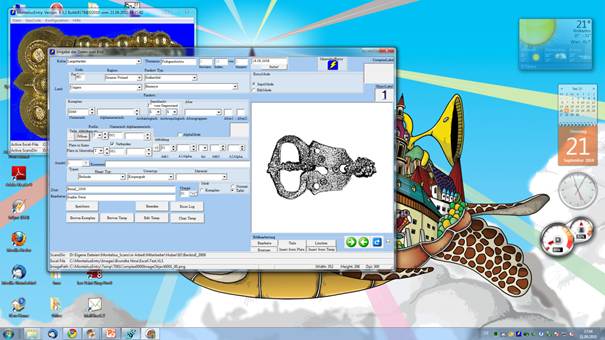
These inputs in an
image database Montelius are essential for a quantitative evaluation. In
between is but one more step, namely the setup of a (fine) typology! With our proprietary program
MonteliusEditor it is now possible to create this much faster than it was
possible with the previous conventional type plates (on paper). All participants in our seminar on
quantitative methods held in Vienna in winter semester, have seen how easy it
is to setup typology through drag ‘n drop of images with the mouse into newly
created folders with descriptive names. We have been doing these (PhD-Training)
seminars also at the universities of Munich, Graz, Nitra and Budapest. We offer to hold them also elsewhere.
Fig.2, MonteliusEditor with
the view of the typology:
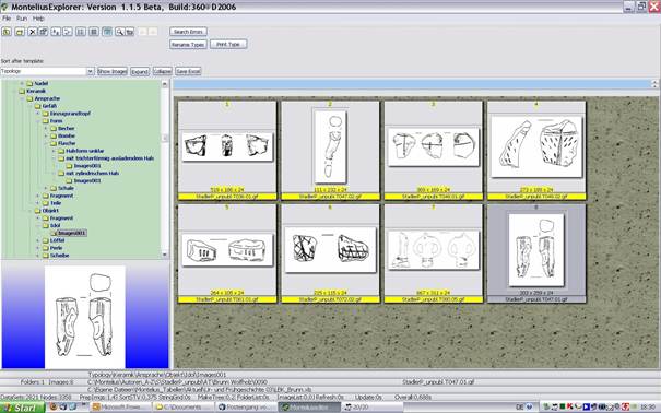
Typological features with MonteliusEditor and with "Drag 'n
Drop".
·
The acquisition of an object
took on average 60 seconds. Through the use of new programs
(MonteliusImageAnalyzer etc.) it should be accelerated significantly.
·
The search for parallels of an
object takes about 30 seconds (compared to weeks of searching in the library).
·
The assignment of an image to an
existing type is possible in a few seconds more.
·
A new type is easily setup by
creating a new "Directory" in MonteliusEditor with an appropriate
descriptive name.
·
An existing type can easily be
split into two sub-types.
·
The main advantage over a
conventional typology is that the working process is hundred times faster.
·
Thus, in the last 9 years could
be entered about 750.000 objects most from Protohistory of Central Europe.
·
A Part of it (ca. 200.000
objects) could already be ordered typologically.
So far, the image
data of 21,000 sites in Central Europe are covered. These sites were geo-coded
with GoogleMaps, by using the known address details from the database
automatically. This is performed by our program MonteliusEntryGoogleCode. Our
program GoogleMapper allows the captured data to be mapped to any portion of
Google Maps. To better explain just a few examples:
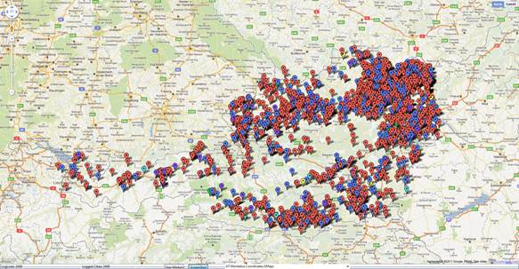
Fig. 3, Svend Hansen has gathered
in his habilitation in 2007 on the Paleolithic and Neolithic idols an
incredible wealth of material. This
illustrates our map here:
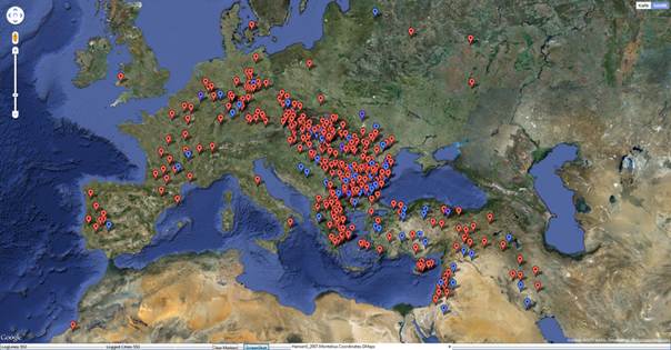
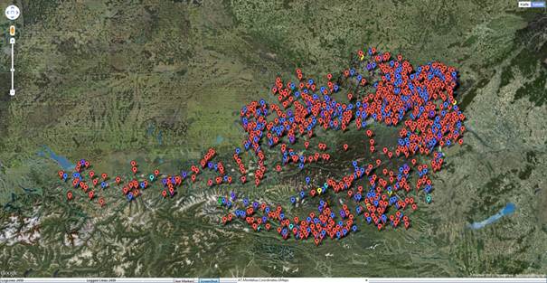
Fig. 4, All currently
registered 2459 sites in Austria show which parts of the country were settled
preferably:
Even Germany and Hungary, like
many other countries of Central Europe are already covered quite well:
Fig. 5, Here Germany with
3972 sites:
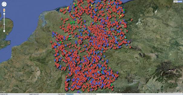
Fig. 6, Here Hungary with
3393 sites:
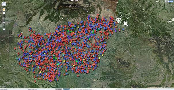
Fig. 7, In addition, we can
map sites of whole cultures, here Lombards (or Lombard time) finds:
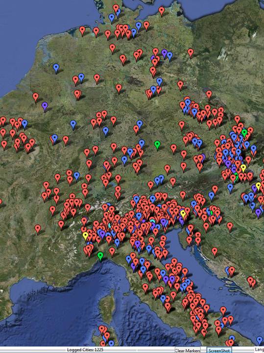
Fig. 8, Of course it is possible, to map all with
MonteliusEditor setup types, here an example of the Avars: Armreif00150 a
bracelet of Keszthely group in the Avar Empire is given (there are currently
about 6,000 such Avar time maps:
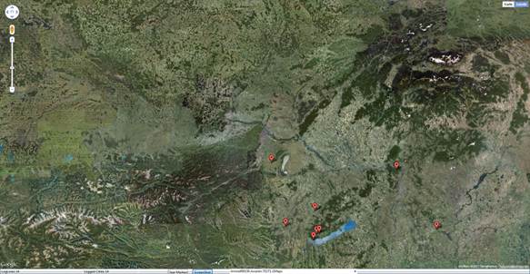
Fig. 9, Besides it is also
possible, as Google Maps permits, to map not only on the basis of satellite
photos, but on a normal map and a relief map: